 |
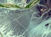
On a lonely stretch of the Pan-American Highway, 275 miles south of Lima, Peru, lies a town called Nasca. The town sits in the Pampa region, a desolate plain on the northern tip of the Atacama Desert. What makes this area unique is the Nasca Lines -- a spider’s-web of lines and shapes crisscrossing 250 square miles of bone-dry desert. Their origin and purpose has baffled scientists and laymen alike since their “discovery” in the 1920s.
The Nasca Lines consist of trapezoids and spirals, giant animal and humanoid figures, and ruler-straight lines that stretch for miles. These lines and ground drawings, called "geoglyphs,” are attributed to the Nasca race that populated this land between 200 B.C. and 600 A.D. They were created by removing the top layer of dark rock from the desert floor, revealing contrasting white-yellow sand. Interestingly, the drawings are best viewed and appreciated from the air.
Average rainfall in this desert is half an inch per year. Widely recognised as the driest place on earth, the Atacama’s Nasca Lines have been preserved for thousands of years.
When commercial airlines started flights over the Peruvian desert in the 1920s, pilots and passengers spoke of seeing “landing strips” crisscrossing the ground below. Stories of these mysterious lines soon spread. Many experts have since then attempted to unravel the puzzle of the desert drawings.
Dr. Paul Kosok came to the Nasca desert in the 1930s to study ancient irrigation channels. Initially, the Nasca Lines were thought to be remnants of these channels. Often travelling by foot, Dr. Kosok soon discovered large-scale drawings of animals and other objects. Over time, he theorised that the drawings represented a large astronomical chart.
In the mid-1940s, a German girl named Maria Reiche worked to further develop Dr. Kosock’s astronomical theory. Her background in mathematics and astronomy enabled her to map and study the desert shapes. She noted that many lines aligned with important solstices, and discovered further correlations to the solar cycle. She found large drawings of a monkey, whale, spider and several birds. While painstakingly clearing, measuring and reproducing the lines on paper, she discovered a standard of measurement used by the ancient artists. In 1977, she published a book, “Mystery On The Desert,” summarising her research of the Nasca Lines. She continued her research until her death in 1998.
Other experts had different theories. Toribio Nejia, a renowned Peruvian archaeologist, proposed the lines were sacred pathways, or “ceques,” and the clearings used for ritual gatherings. Author Erich von Daniken made one of the more fanciful speculations in his book "Chariots of the Gods ?" He speculated that the lines were laid out for alien spacecraft to land on the desert.
Although many theories abound to the purpose of these strange markings, there remains no consensus as to their meaning.
As these different researchers brought more attention to the Nasca Lines, the normally lonely desert was suddenly under threat. As she did years earlier when the lines were threatened by a government scheme to irrigate the arid pampa, Maria Reiche was able to spearhead an effort to preserve these unique markings by restricting crowds driving through the fragile terrain. In 1994, the Lines of Nasca were designated a World Heritage site by the United Nations Educational, Scientific and Cultural Organisation.
To this day, the Lines of Nasca remain a mysterious remnant from an ancient civilisation.
* * *
You are welcome to print and circulate all articles published on Clearharmony and their content, but please quote the source.


 more ...